English
Thingeyjarsveit Office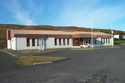
Laugum
Address: Kjarni, 650 Laugum
Minicipality number: 6612
Phonenumber: 464-3322
Fax: 464-3422
E-mail: thingeyjarsveit@thingeyjarsveit.is
Opening hours are weekdays 09:00- 12:00 and 12:30 - 15:00.
Following are some interesting facts about our community:
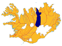
Thingeyjarsveit Municipality came into existence in June 2002 with the merger of four parishes: Hálshreppur, Ljósavatnshreppur, Bárddaelahreppur and Reykdaelahreppur. In 2008 Thingeyjarsveit and Adaldaelahreppur merged into one Municipality under the name Thingeyjarsveit. The population is about 900, and the area is 6000 km2.
The people are thriving and the economic possibilities diverse, such as in agriculture, education, fish processing, forestry, the tourism industry, food production, etc. The municipality has a compulsory school and preschool: Stórutjarnaskóli and Litlulaugaskóli. It also has the Laugar Upper Secondary School and the Music School in Laugar, in addition to the Music Department at Stórutjarnaskóli. There are camps for schoolchildren in Bárdardalur. Theatre and singing are in full bloom, and sports activities are vigorous. You enter Thingeyjarsveit Municipality on the west side of Víkurskard on the parish boundary of Grýtubakkahreppur, and you then head east to Fnjóskadalur Valley. Fnjóskadalur is about 40 km long, and flowing through it is the Fnjóská River, the longest spring-fed river in Iceland. There are good campsites in the valley. There is a dense summer cottage settlement and a swimming pool at Illugastadir. Many places have forest cover, and the biggest birch forest in Iceland is found there: Vaglaskógur. Flateyjardalur Valley, once populated, is now deserted; it is about 32 km north ofFnjóskadalur at Dalsmynni and reaches to the sea. The last farm, Brettingsstadir, was deserted in 1954. The route into the valley runs just south of Thverá River in Dalsmynni; it is only passable in the summer and then only in jeeps or larger vehicles. The island Flatey á Skjálfanda is about 2.5 km where it is longest and about 2 km where it is widest. People lived on Flatey continuously from the 12th century to 1967. Its population peaked in 1943 at about 120 people. Thingeyjarsveit has since reached from Flatey south to Vatnajökull Glacier.
Ljósavatnsskard Pass stretches east from Fnjóskadalur Valley, connecting it with Bárdadalur Valley and Kaldakinn. Lake Ljósavatn lies in the mouth of the pass to the east. Djúpá River flows into Skjálfandafljót on the east side of Mt. Kinnarfell. Kambsá River flows into Lake Ljósavatn. Thingmannalækur Brook runs through Ljósavatnsskard Pass into Fnjóská River. In the pass are Stórutjarnaskóli School and an urban core, a hotel in the summer and a swimming pool. Thorgeirskirkja Church, in Ljósavatnsskard, was built to commemorate Icelanders' Christianisation in the year 1000; it is named after the chieftain Thorgeir Ljósvetningagodi, who decided that Icelanders would be of one faith, Christianity, instead of heathenism. The church is open to tourists in the summer. Kaldakinn is the name of the settled area north of Ljósavatnsskard, stretching from west of Skjálfandafljót to the sea, beneath the steep slopes of Kinnarfjöll Mountains. The Federation of Icelandic Cooperatives (SÍS) was founded at Yztafell in 1902. There is a Museum of Communications there. Farthest north, in the area called Út-Kinn, is Náttfaravíkur.Náttfari settled there; he was one of Gardar Svavarsson's men, who was the first person to winter in Iceland. The roots of Mt. Kinnarfell are just north of the mouth of Ljósavatnsskard Pass, which continues running north from the middle of the countryside. Skjálfandafljót flows east of the mountain, and there, opposite Fellsskógur, is Thingey.This was the sight of an ancient thing where a local parliament was held each spring. Thingey was probably a parliamentary site from 963 on. The island is nearly 6 km long, for a broad peninsula, where the site of the parliament was, reaches east from it. The name there is Thinghóll , which clearly forms space for large tents and a round wall around them. Thingeyjarsýslur Districts as well as Thingeyjarsveit take their names from the island. North of Thingey is Skuldathingey, which also has ancient relics.
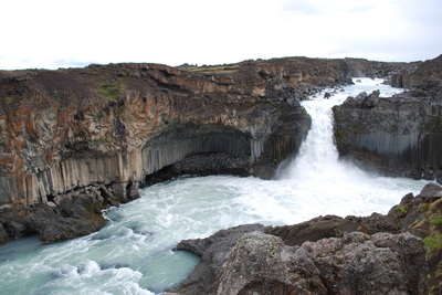
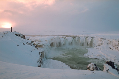
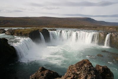
Bárdardalur Valley is one of the oldest settled valleys in Iceland; it is about 45 km long, and Skjálfandafljót flows along its bottom. Godafoss Falls is regarded as one of the most beautiful waterfalls in Iceland, and it is right next to Highway 1 at Fosshóll. Cliffs at the edge of the falls divide it into two main waterfalls, 9 and 17 m high, and several smaller ones. A story says that Thorgeir Ljósvetningagodi threw his gods into the waterfall after Christianity was made law in 1000, and the waterfall got its name from this event. There are several caves in the rock down by the river. One of these caves is called Sölvahellir, for a story says that in this cave lived an outlawed robber, named Sölvi, for a time until he was found and killed. There are more falls farther north in the river, such as Barnafoss and Ullarfoss. Barnafoss is on the east side of Mt. Kinnarfell, opposite of the abandoned farm Barnafell. The waterfall is said to get its name from when children were once playing in a barrel a short way from the waterfall and the barrel rolled into the canyon with them inside, and they perished. Hrifla is a farm west ofSkjálfandafljót. Jónas Jónsson (1885-1968) was born there. He was a school principal and minister, better known as Jónas from Hrifla. Kidagil is on the Sprengisandur Route; Grímur Thomsen made Kidagil immortal in his poem Sprengisandur: "I would give my most treasured horse to be safely arrived in Kidagil," says the poem, quoting a traveller on horseback who is beginning to pine for reaching a settled area. Aldeyjarfoss is a beautiful waterfall in a strange environment of basalt columns and potholes. It is on the west side of the valley, about 1 km south of Mýri, at the start of Sprengisandur Route. A little above it is Ingvararfoss Falls and still farther upriver Hrafnabjargafossar Falls.
East of Fljótsheidi and south of Adaldalur Valley lies Reykjadalur Valley. The municipal boundary with Adaldaelahreppur Parish is at Lake Vestmannsvatn. The valley is quite wide at its farthest point but narrows at Breidumýri, with Fljótsheidi to the west and Laxárdalsheidi and Mývatnsheidi to the east at the parish boundary with Skútustadahreppur. Reykjadalur Valley is grassy and fairly urban, and Reykjadalsá River runs through it. Laugar is the urban core in Reykjadalur. Althýduskóli School was opened there in 1925, later becoming a district school, and in 1928 a home economics school was also built there. An upper secondary school was then founded in 1988. It is in a beautiful environment and is a popular country boarding school. In Laugar there is a preschool, compulsory school and music school, a store, savings and loan association, post office and workshop. A new swimming pool was opened in the summer of 2005. The fish-drying company Laugafiskur hf. is in Laugar; it sells its products in Nigeria. The poet Sigurjón Fridjónsson (1867-1950) lived for a long time in Litlulaugar. Laxárdalur Valley is about 27 km long; lying east of Reykjadalur, it reaches from Brýr í Adaldal to Helluvad in Mývatnssveit. The valley is renowned for its natural beauty. It is lushly vegetated, and Laxá River runs through it into Laxárgljúfur Canyon in Adaldalur. On Thverá River in Laxárdalur Valley, a remarkable turf-roofed farm has been preserved as well as out-buildings made in the same form. There, Kaupfélag Thingeyinga (co-operative store for the area) was founded in 1882. The church on Thverá River, which is made of chiselled stone, was built in 1878. Arngrímur Gíslason painted the altarpiece. Old churches, both beautiful and remarkable, are found in many places in Thingeyjarsveit.